This fact sheet can be used as ten minute GIS tutorial. It explains the key terms and concepts of Geographical Information Systems in a quick and easy way. Read this and gain sufficient understanding of GIS to call any bluffs or ask important questions. This GIS tutorial is useful for managers, professionals and educators alike.
Download files
Fact sheet sample
GIS is an abbreviation for Geographic Information System, a term used to describe data, software and processes which allow you to look at and query map based information on a computer screen.
What is GIS
GIS is an abbreviation for Geographic Information System, a term used to describe data, software and processes which allow you to look at and query map based information on a computer screen.
GIS is mainly used as an easy way of making maps professional-looking maps.
GIS Fundamentals
GIS mimics paper maps.
In paper maps, colored areas and lines are drawn on top of each other on a plane surface, resulting in a map image which may be printed.
A GIS combines features consisting of geometry and associated information by stacking them on top of each other – resulting in the display of a map image on a computer screen.
Features which have the same type of geometry and the same set of attributes are combined into feature classes.
Think of a forest feature class as a table where each record represents a feature. The first column holds the geometry of the forested area; subsequent columns contain information about the area – attributes– such as type and sub-type of trees.
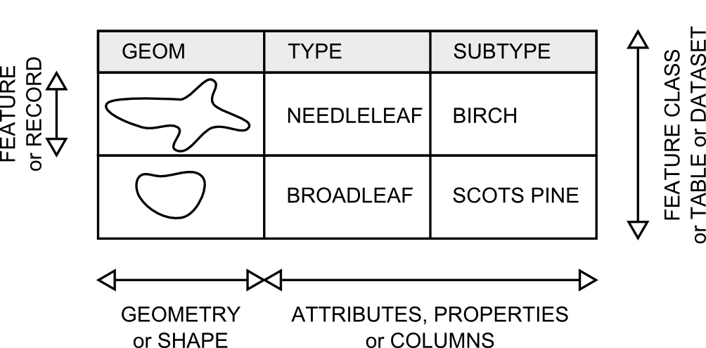
GIS tutorial: what is a feature, what is a featureclass and what is an attribute
Recommended reading
This GIS factsheet is a good starting point for getting a high-level understanding of GIS for managers or learn GIS for aspiring GIS experts or professionals in other domains who have to relate to GIS experts.
ESRI ArcGIS 10 tutorials (commercial)
In many parts of the world, GIS is synonymous with ArcGIS software from Environmental Systems Research Institute (ESRI). However irritating for competitors, this reputation is not unjust and has been earned by the personal commitment and dedication of ESRI CEO Jack Dangermond and his team.
At MapIT.biz, we like open source, however, when it comes to desktop software for spatial data creation, visualization, analysis and maintenance, ArcGIS have no contenders in terms ease of use. ArcGIS has a hefty price tag – but it is to be noted that almost all desktop GIS software in existence are mimicking ArcGIS.
The price you are paying when buying ArcGIS is contributing to innovation across the entire GIS community both in the open source and commercial camps.
A tutorial book for ArcGIS 10, the latest incarnation of the ArcGIS platform (2012), as well as the possibility to request a 180-day trial version of the ArcGIS software package can be found at http://esripress.esri.com
Quantum GIS tutorial (open source)
One of the most promising and powerful open source GIS desktop software is Quantum GIS. While not as usable as ArcGIS, this application has the major advantage that it is free. With a skilled GIS expert, almost all professional GIS tasks may be done using Quantum GIS. All causal GIS user tasks such as viewing and querying thematic maps are straightforward. It is likely that hybrid GIS infrastructures will emerge where free software like Quantum GIS is deployed to casual GIS users who simply need to view and query maps whereas GIS experts will used ArcGIS to do advanced GIS work.
Download Quantum GIS from http://www.qgis.org/ and try the QGIS tutorial (revised for QGIS 1.4) by Amanda Wallace and Thomas R. Mueller. Department of Earth Sciences, California University of Pennsylvania.